wrf专题

WRF-LES与PALM微尺度气象大涡模拟
针对微尺度气象的复杂性,大涡模拟(LES)提供了一种无可比拟的解决方案。微尺度气象学涉及对小范围内的大气过程进行精确模拟,这些过程往往与天气模式、地形影响和人为因素如城市布局紧密相关。在这种规模上,传统的气象模型往往难以捕捉到详细的湍流细节和微观气象变化。大涡模拟通过直接解析大尺度湍流涡旋,而将较小尺度的湍流效应通过亚格子模型来参数化,从而在保持计算可行性的同时,提供了对这些复杂动态的深入理解。

WRF-LES与PALM微尺度气象大涡模拟实践技术应用
针对微尺度气象的复杂性,大涡模拟(LES)提供了一种无可比拟的解决方案。微尺度气象学涉及对小范围内的大气过程进行精确模拟,这些过程往往与天气模式、地形影响和人为因素如城市布局紧密相关。在这种规模上,传统的气象模型往往难以捕捉到详细的湍流细节和微观气象变化。大涡模拟通过直接解析大尺度湍流涡旋,而将较小尺度的湍流效应通过亚格子模型来参数化,从而在保持计算可行性的同时,提供了对这些复杂动态的深入理解。
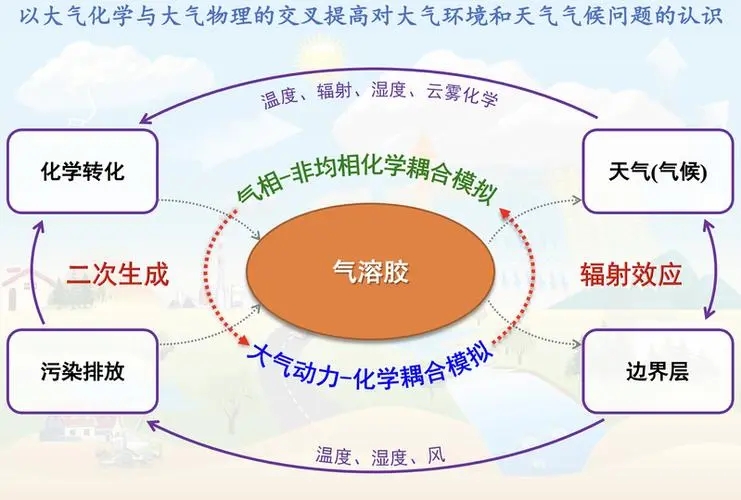
空气质量预报模式系统WRF-CMAQ
空气污染问题日益受到各级政府以及社会公众的高度重视,从实时的数据监测公布到空气质量数值预报及预报产品的发布,我国在空气质量监测和预报方面取得了一定进展。随着计算机技术的高速发展、空气污染监测手段的提高和人们对大气物理化学过程认识的深入,开发并利用先进的大气化学模式进行我国空气质量的预测预报、对于减少大气污染灾害、提高人民生活质量都具有积极的意义。空气质量预报模式系统(WRF-CMAQ)和污染源处理
nesting in wrf
Choices for Nesting are:0 no nesting (only available for serial and smpar) 0. no nesting (only available for serial and smpar)1. basic2. preset moves preset moves3. vortex following• default is opti

【WRF理论第二期】运行模型的基础知识
WRF理论第二期:运行模型的基础知识 1 Basics for Running the Model2 Geogrid程序2.1 Geogrid2.2 Terrestrial Input Data 3 Ungrid程序3.1 Ungrid3.2 Intermediate Files3.3 Required Fields 4 Metgrid程序参考 官方介绍-Basics for Ru

【WRF理论第四期】namelist.wps文件详述
WRF理论第四期:namelist.wps文件详述 1 namelist.wps 的主要部分1 &share2 &geogrid3 &ungrib4 &metgrid示例 namelist.wps 文件参考 namelist.wps 文件是 WRF Preprocessing System (WPS) 的关键配置文件,用于设置地理数据和气象数据预处理的参数。 它包含多个部分,每个

【WRF调试运行第一期】安装WRF模型所需平台
WRF实践实操第一期:安装WRF模型所需平台 1 操作系统2 先决条件软件3 程序流(Program Flow)4 文件说明软件安装1-Cygwin参考 安装 WRF(Weather Research and Forecasting)模型需要准备适当的硬件和软件平台。 相关介绍可参见-WRF-ARW Online Tutorial 1 操作系统 WRF 模型主要在类 UNIX
【WRF理论第二期】模型目录介绍
WRF理论第二期:模型目录介绍 1 WRF主目录2 WPS主目录3 编译后的可执行文件4 运行目录参考 了解 WRF 模型的目录结构有助于有效地管理和操作模型,从而确保模拟和分析工作的顺利进行。以下分解介绍WRF主目录、WPS主目录等。 Github-wrf-model/WRF 1 WRF主目录 安装 WRF 模型后,通常会在特定目录下形成一系列文件和子目录,这些目录结构帮
如何在WRF模型中更好地设置这些海洋物理参数以提高模拟精度?
在WRF(Weather Research and Forecasting)模型中正确设置海洠物理参数是提高模拟精度的关键,特别是当模拟涉及到海洋和大气的相互作用时。以下是一些提高模拟精度的策略和建议: 1. 理解模拟的地区和目标 在进行参数设置之前,重要的是要充分理解模拟的地理区域特征和研究目标。例如,如果你的研究关注于海洋边缘区域,那么海洋物理过程的影响可能非常显著,需要更精细的调整。 2
NCL绘制WRF domain区域并添加气象站点
读取文件 根据官网例子Using gsn_csm_contour_map to plot WRF-ARW data绘制: ; It shows how to use gsn_csm_xxxx scripts to do the plotting.;; You can use the map projection settings on the WRF file, or you; can

【C++风云录】改变气候研究游戏规则:CLM、CESM、WRF、CDO、MPAS和NCL的全面指南
科技与气候:六大工具的洞察和应用 前言 在当前的科技环境中,模型和软件工具对于理解和预测天气,气候变化以及其他地球系统现象起着至关重要的作用。本文将详细介绍六种不同的工具:CLM, CESM, WRF, CDO, MPAS 和 NCL,并探讨它们在相关领域的应用。 欢迎订阅专栏: 文章目录 科技与气候:六大工具的洞察和应用前言1. CLM(Community Land Mod
【WRF】将modis数据2019年中国土地利用数据处理成wrf能识别的土地利用数据
step1、利用gee获取2020年中国区域的土地利用数据 //get a feature collection with china square boundaryvar china_square = ee.FeatureCollection('projects/hsy/assets/chinashp_square');//load modis land cover datavar mod
RAMS (Mesoscale Model System) 和 WRF 区别
历史和发展: RAMS:RAMS 最早于1970年代由美国科罗拉多州立大学开发,并在之后几十年不断发展壮大。它是最早用于模拟地区尺度大气动力学、热力学和降水过程的模型之一。WRF:WRF 是由美国国家大气研究中心(NCAR)等机构开发的现代化天气研究和预报模型。它是基于NCAR的MM5(Mesoscale Model 5)模型发展而来,于2008年发布。 物理方案和参数化: RAMS:RAMS
表面强迫1:用于表面施力的WRF模型配置
WRF大气模型 概述了如何使用WRF为FVCOM生成强制。 下载 WRF 需要注册才能下载代码。 为了以最小的运行模型运行,您需要下载: WRF-ARW-主要的WRF模型 WPS -WRF预处理工具 geog-地理数据。使用完整数据集(约48GB未压缩)或最小数据集(小得多)。 WRF还需要一些库: netCDF JasPer zlib libpng m
双碳目标下基于全球模式比较计划CMIP6与区域气候-化学耦合模式WRF-Chem的未来大气污染变化模拟教程
原文链接:双碳目标下基于全球模式比较计划CMIP6与区域气候-化学耦合模式WRF-Chem的未来大气污染变化模拟教程https://mp.weixin.qq.com/s?__biz=MzUzNTczMDMxMg==&mid=2247599209&idx=7&sn=2fb78bcb18e6ec709853a7595d8822d9&chksm=fa82058ecdf58c9852bf40b62a819
Python - 从WRF输出文件中提取变量(如经向风、比湿和温度),进行插值处理,并将结果保存到一个NetCDF文件
该代码的作用是从WRF输出文件中提取变量(如经向风、比湿和温度),进行插值处理,并将结果保存到一个NetCDF文件中。 将重复的代码抽取到单独的函数中,以提高代码的重用性和可读性。统一了变量命名风格,使用了下划线命名法。添加了对文件的打开和关闭,以及错误处理机制。添加了详细的文档字符串,描述了每个函数的作用、参数和返回值。使用了 main() 函数来组织主要的执行逻辑。 import xarr
WRF模型运行教程(ububtu系统)--III.运行WRF模型(官网案例)
零、创建DATA目录 # 1.创建一个DATA目录用于存放数据(一般为fnl数据,放在Build_WRF目录下)。mkdir DATA# 2.进入 DATAcd DATA 一、WPS预处理 在模拟之前先确定模拟域(即模拟范围),并进行数据预处理(插值陆面数据,比如地形,土壤等数据;插值气象数据到模拟域)。 (一)解压GRIB数据(ungrib.exe) I.解压G
WRF模型教程(ububtu系统)-WPS(WRF Pre-Processing System)概述
一、WPS简介 WRF 预处理系统 (WRF Pre-Processing System,WPS) ,集成了基于Fortran和C编写的程序,这些程序主要用于处理输入到real.exe的数据。WPS主要有三个程序和一些辅助程序。 二、各程序介绍 主要的程序为geogrid.exe、ungrib.exe、metgrid.exe,输入到这些程序的配置在“namelist.
WRF模型运行教程(ububtu系统)--II.ARWpost安装
一、ARWpost简介 ARWpost 是一个把 WRF 结果转为 GrADS 或 Vis5D 可以辨识的数据格式的软件,就是WRF运行结束以后,把WRF的结果变成咱们平时比较常用的数据格式。 二、下载和安装ARWpos_V3 1.ARWpos_V3安装前准备 # 进入Build_WRF文件夹cd Build_WRF# 下载ARWpos_V3wget https://ww

WRF土地利用数据替换
WRF更换土地利用数据 文章目录 WRF更换土地利用数据前言一、数据下载二、GRID转tiff三、重投影四、重分类五、tiff格式转二进制六、修改GEOGRID.TBL七、修改namelist.wps八、运行geogrid.exe 前言 近期利用WRF进行辐照度模拟,苦于精度提升慢,所以想利用中国土地利用数据(1980-2015)的土地利用数据替换wrf内老旧的土地利用
【python-wrf】绘制wrf中的土地利用报错内容及其解决方法
从该代码处绘制wrf中的土地利用报错内容及其解决方法 1.报错内容: 微信公众平台 (qq.com)https://mp.weixin.qq.com/s/Cn0vhvfroVADPnT237LXNw ---------------------------------------------------------------------------AttributeError
WRF报错: ERROR: The mandatory field TT was not found in any input data.
运行WPS时, ./metgrid.exe 运行出错,查看 WPS目录下的 metgrid.log,发现最后一行显示: ERROR: The mandatory field TT was not found in any input data. 检查namelist.wps发现报错的文件名的格式和其余文件不一样,发现是之前下载的数据不全报错以后,更改了新的数据,然后没有更改文件的名字,导致出现
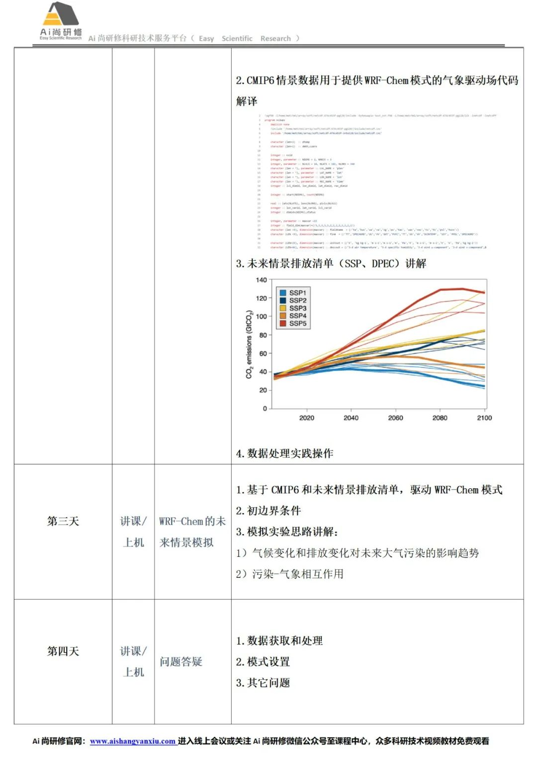
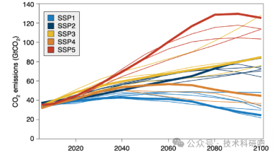
全球模式比较计划CMIP6与区域气候-化学耦合模式WRF-Chem的未来大气污染变化模拟
国家碳达峰碳中和(双碳)目标对未来大气污染控制提出了新的要求,也为未来气候变化背景下,大气环境演变趋势和空间格局的模拟和预估提出了不确定性和挑战。第六次国际耦合模式比较计划(CMIP6)基于不同的共享社会经济路径(SSP)及最新的人为排放趋势,预估了不同社会共享路径和温室气体排放情景下的未来气候变化趋势,这些结果为模拟预估未来气候变化背景下大气污染的演变趋势提供了可能。对模式比较计划的全球气候预估

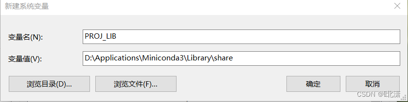
【编程BUG解决】WRF-Python库导包报错解决
一、问题描述 在处理wrfout数据绘制剖面图时,用到了wrf-python库,导入其中的部分涉及Basemap的库时报错:KeyError: 'PROJ_LIB',具体信息如下: 二、原因分析 从上图提升信息pyproj_datadir = os.environ['PROJ_LIB']看出,应该是找不到PROJ_LIB这个环境变量,该环境变量用于设置proj4模块(Basemap模块的依
WRF如何批量输出文件添加或删除文件名后缀
1. 批量添加文件名后缀 #1----批量添加文件名后缀(.nc)。#指定wrfout文件所在的文件夹path = "/mnt/wtest1/"#列出路径path下所有的文件file_names = os.listdir(path) #遍历在path路径下所有以wrfout_d01开头的文件,在os.path.basename()返回的一个代表指定路径基本名称的字符串值后加入“.nc”