本文主要是介绍java计算不规则多边形的面积、中心、重心(计算地图围栏中心点),希望对大家解决编程问题提供一定的参考价值,需要的开发者们随着小编来一起学习吧!
最近项目用到:在不规则多边形的中心点加一个图标。(e.g: xx地区发生暴雪,暴雪区域是多边形,给多边形中心加一个暴雪的图标)
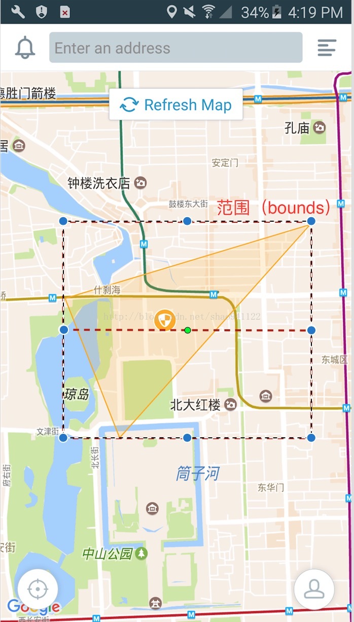
之前的设计是,计算不规则多边形范围矩形bounds的中心点。这个比较简单,对于一些圆,矩形,凸多边形都比较适合。但是遇到凹多边形就会出现问题,比如一个月牙型的不规则多边形,bounds的中心点,就落到月牙外了。就有点难以接受了。
经过讨论,决定将中心改为重心。
计算不规则多边形的中心:
public static final double MIN_LAT = -90;
public static final double MAX_LAT = 90;
public static final double MIN_LNG = -180;
public static final double MAX_LNG = 180;  /** * 获取不规则多边形几何中心点 * * @param mPoints * @return */
public static LatLng getCenterPoint(List<LatLng> mPoints) {  // 1 自己计算  // double latitude = (getMinLatitude(mPoints) + getMaxLatitude(mPoints)) / 2;  // double longitude = (getMinLongitude(mPoints) + getMaxLongitude(mPoints)) / 2;  // return new LatLng(latitude, longitude);  // 2 使用Google map API提供的方法(推荐)  LatLngBounds.Builder boundsBuilder = LatLngBounds.builder();  for (LatLng ll : mPoints)  boundsBuilder.include(ll);  return boundsBuilder.build().getCenter();
}  // 经度最小值
public static double getMinLongitude(List<LatLng> mPoints) {  double minLongitude = MAX_LNG;  if (mPoints.size() > 0) {  minLongitude = mPoints.get(0).longitude;  for (LatLng latlng : mPoints) {  // 经度最小值  if (latlng.longitude < minLongitude)  minLongitude = latlng.longitude;  }  }  return minLongitude;
}  // 经度最大值
public static double getMaxLongitude(List<LatLng> mPoints) {  double maxLongitude = MIN_LNG;  if (mPoints.size() > 0) {  maxLongitude = mPoints.get(0).longitude;  for (LatLng latlng : mPoints) {  // 经度最大值  if (latlng.longitude > maxLongitude)  maxLongitude = latlng.longitude;  }  }  return maxLongitude;
}  // 纬度最小值
public static double getMinLatitude(List<LatLng> mPoints) {  double minLatitude = MAX_LAT;  if (mPoints.size() > 0) {  minLatitude = mPoints.get(0).latitude;  for (LatLng latlng : mPoints) {  // 纬度最小值  if (latlng.latitude < minLatitude)  minLatitude = latlng.latitude;  }  }  return minLatitude;
}  // 纬度最大值
public static double getMaxLatitude(List<LatLng> mPoints) {  double maxLatitude = MIN_LAT;  if (mPoints.size() > 0) {  maxLatitude = mPoints.get(0).latitude;  for (LatLng latlng : mPoints) {  // 纬度最大值  if (latlng.latitude > maxLatitude)  maxLatitude = latlng.latitude;  }  }  return maxLatitude;
}
计算不规则多边形的重心:
/** * 获取不规则多边形重心点 * * @param mPoints * @return */
public static LatLng getCenterOfGravityPoint(List<LatLng> mPoints) {  double area = 0.0;//多边形面积  double Gx = 0.0, Gy = 0.0;// 重心的x、y  for (int i = 1; i <= mPoints.size(); i++) {  double iLat = mPoints.get(i % mPoints.size()).latitude;  double iLng = mPoints.get(i % mPoints.size()).longitude;  double nextLat = mPoints.get(i - 1).latitude;  double nextLng = mPoints.get(i - 1).longitude;  double temp = (iLat * nextLng - iLng * nextLat) / 2.0;  area += temp;  Gx += temp * (iLat + nextLat) / 3.0;  Gy += temp * (iLng + nextLng) / 3.0;  }  Gx = Gx / area;  Gy = Gy / area;  return new LatLng(Gx, Gy);
}
其中LatLng类-就是一个包含经纬度点的简单类。可以自己创建一个包含 x ,y 的类代替。
public final double latitude;
public final double longitude;
通过这张图,就可以发现中心和重心的区别了

这篇关于java计算不规则多边形的面积、中心、重心(计算地图围栏中心点)的文章就介绍到这儿,希望我们推荐的文章对编程师们有所帮助!


