geotools专题
解决Java中基于GeoTools的Shapefile读取乱码的问题
《解决Java中基于GeoTools的Shapefile读取乱码的问题》本文主要讨论了在使用Java编程语言进行地理信息数据解析时遇到的Shapefile属性信息乱码问题,以及根据不同的编码设置进行属... 目录前言1、Shapefile属性字段编码的情况:一、Shp文件常见的字符集编码1、System编码
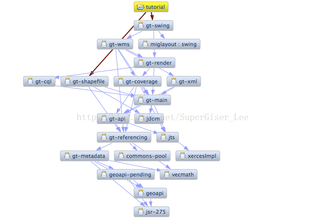
Java GIS开发工具包-GeoTools浅谈
目录 前言 一、关于Geotools 1、GeoTools简介 2、官方仓库 3、使用Geotools的一些项目 二、Geotools架构 1、功能架构 2、Geotools支持的数据格式 三、Geotools科研热点 1、知网信息 2、百度学术 四、总结 前言 地理信息,智联万物。地理信息在我们的生活中无处不在,随着我们的出生,我们
自定义类加载器使用geotools读取高程报 ImageRead: No OperationDescriptor is registered 问题
背景 项目中使用了 自定义classLoader ,,然后使用下面简化后的代码读取高程数据 public class Test{public static void main(String[] args) throwS Exception{CustomClassLoader cl = new CustomClassLoader();Class<?> clazz = cl.loadClass
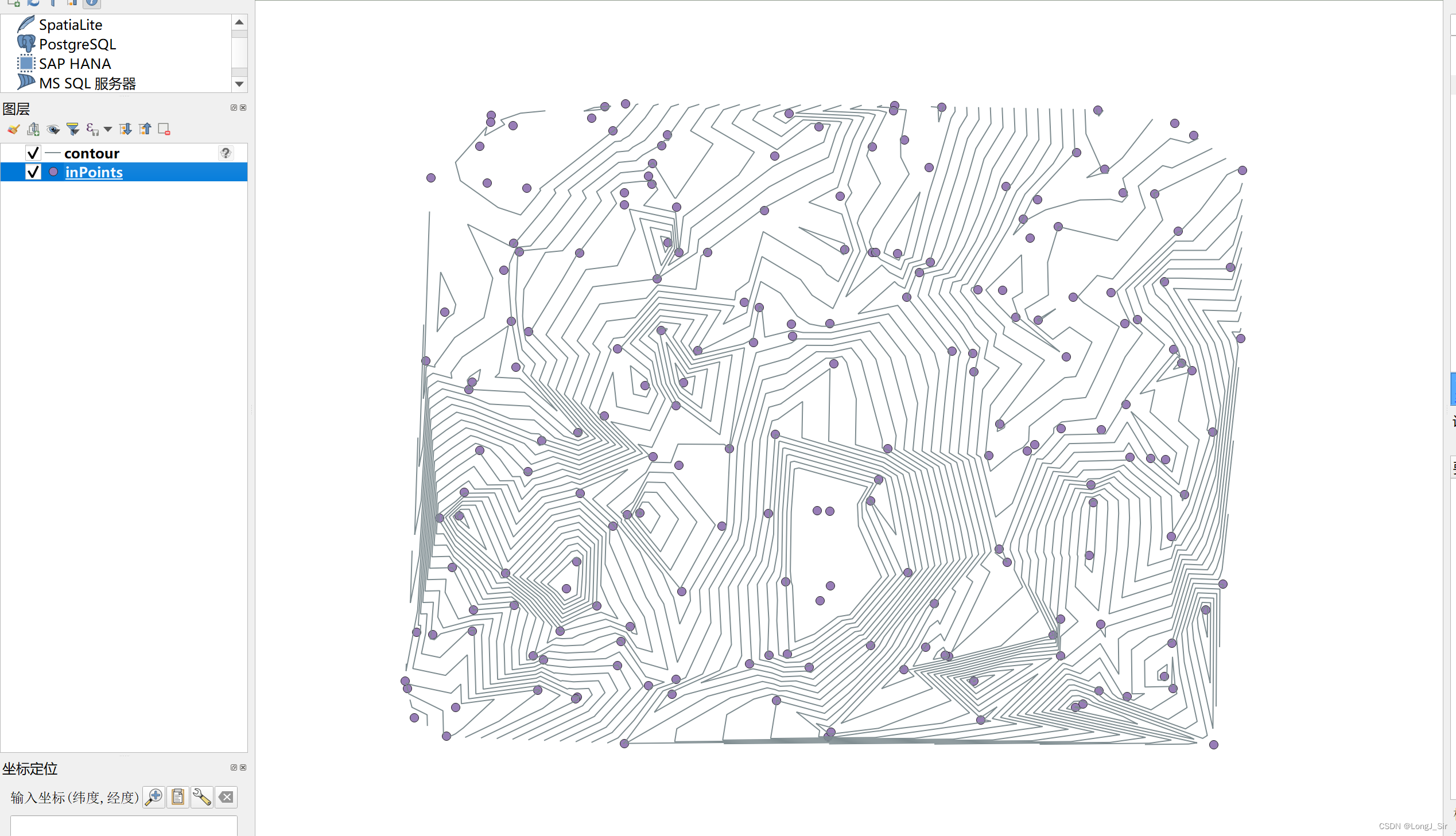
Geotools--生成等值线
好久没用geotools去写东西了,因为近几年一直在接触所谓数字孪生和可视化相关项目,个人的重心也往前端可视化去倾斜,在后端的开发上到变得停滞下来。 这次用的是geotools 28.4版本,生成等值线的方法在 <dependency><groupId>org.geotools</groupId><artifactId>gt-process-feature</artifactId><ve
【GIS系列】GeoTools简介及工具类分享
本文将对GeoTools相关概念进行介绍,同时会给大家分享我工作中用到的工具类及使用方法。 作者:后端小肥肠 目录 1.前言 2. GeoTools简介 3. Geotools使用示例 3.1. 开发环境搭建 3.1.1. 所需版本和工具 3.1.2. pom依赖 4. 工具类介绍 4.1. 读取shp工具类 4.1.1 准备数据 4.1.2. 部分方法
GeoTools应用-(JTS Geometry Operations)(二)
一些高级操作, Buffer,LineMerger,Polygonization,UnionLine,凹壳分析,Overlays (1)、Buffer,返回的结果是一个Polygon或者 MultiPolygon buffering is an operation which in GIS is used to compute the area containing all points wi
GeoTools Eclipse 快速入门04
我们继续翻译GeoTools官网教程,这节是关于稍微复杂一些的图形操作。 Things to Try Each tutorial consists of very detailed steps followed by a series of extra questions. If you get stuck at any point please ask your instructor;
GeoTools Eclipse 快速入门03
今天,继续翻译我们的教程,这节讲的是第一个应用程序的快速启动(在项目中呈现一个地图) Quickstart Application Now that your environment is setup we can put together a simple Quickstart. This example will display a shapefile on screen. 1.Crea
GeoTools Eclipse 快速入门02
我们继续上节的翻译,GeoTools Eclipse 快速入门,今天开始这部分内容的第二节(向项目中添加Jar包) Adding Jars to your Project The pom.xml file is used to describe the care and feeding of your maven project; we are going to focus on the de
计算已知经纬度的两点距离(两种方法GeoTools和Haversine公式)
计算已知经纬度的两点距离(两种方法) 法一:GeoTools 要使用GeoTools,你需要在Maven项目中添加以下依赖坐标: <dependency><groupId>org.geotools</groupId><artifactId>gt-main</artifactId><version>24.0</version></dependency> 这个依赖坐标指定了GeoTools
Geotools-PG空间库(Crud,属性查询,空间查询)
建立连接 经过测试,这套连接逻辑除了支持纯PG以外,也支持人大金仓,凡是套壳PG的都可以尝试一下。我这里的测试环境是Geosence创建的pg SDE,数据库选用的是人大金仓。 /*** 获取数据库连接资源** @param connectConfig* @return* {@link PostgisNGDataStoreFactory} PostgisNGDataStoreFactory还有
GeoTools实战指南: 空间坐标系-地理信息科学的核心
GeoTools实战指南: 空间坐标系-地理信息科学的核心 引言 在我们的日常生活中,地图、GPS导航和地理位置服务已经变得司空见惯。但是,你有没有想过这些工具背后的工作原理呢?它们都依赖于一种称为"空间坐标系"的关键概念。本文将深入探讨空间坐标系的基础知识和其在地理信息科学中的重要性。 空间坐标系的基础 空间坐标系,简而言之,就是一个定义了空间位置的系统。它可以帮助我们精确地定位地球上的
java读取shp文件_JAVA用geotools读取shape格式文件
Shapefile属于一种矢量图形格式,它能够保存几何图形的位置及相关属性。但这种格式没法存储地理数据的拓扑信息。 其中,要组成一个Shapefile,有三个文件是必不可少的,它们分别是".shp", ".shx"与 ".dbf"文件 .shp— 图形格式,用于保存元素的几何实体。 .shx— 图形索引格式。几何体位置索引,记录每一个几何体在shp文件之中的位置,能够加快向前或向后搜索一个几何体
GeoTools实战指南:使用MapContent加载GeoServer的WMTS服务
目录 GeoTools实战指南:使用MapContent加载GeoServer的WMTS服务1. 引言2. 准备工作2.1 Maven依赖2.2 GeoServer实例 3. 代码解读3.1 定义你的目标3.2 读取图层样式3.3 连接到 WMTS 服务3.4 搜索并加载指定图层3.5 设置视图和渲染3.6 渲染并保存为 PNG 图像 4. 完整代码5. 仓库代码地址 GeoTo


